
|
Manchester and Stockport Canal Society |
6/7/26
Last site update :
The canal was constructed between 1793 and 1797. It left the Ashton Canal at Clayton, passing through Gorton and Reddish before reaching its terminus at the top of Lancashire Hill adjacent to the Nelstrop flour mill with a wharf area between Wharf Street and Gordon Street. The length of the canal from Clayton to Stockport was 4 miles 71 chains. See maps for the canal route passing through Clayton, Gorton and Openshaw, and Stockport and Reddish. In 1798 a bill was introduced to allow the abandonment of the Beat Bank branch and to offer compensation to landowners for damage done and raise another £30,000 to pay off existing debts. The company informed William Halton who owned the collieries at Denton that they could not afford to complete the branch. When Halton opposed the Bill the company offered to give him the unfinished branch because they had obtained enough coal transport business. He refused hoping to get the abandonment defeated but he failed and the Act was passed. At the time of its construction the local area looked completely different than it does today (see map of 1848) comprising generally of an agricultural landscape with little or no industry. Major changes occurred during the 19th century with the construction of new industries which used the canal to transport raw materials and finished goods. As well as goods the canal also transported people to their place of work. In 1849 a steam packet began to move people between Openshaw Bridge and Lancashire Hill, Stockport at a fare of 4d. More locally, a bell rung in a mill tower would ensure the dispatch of a boat to bring workers to work in the local mills. The main reason for building the canal was to move coal from the various coal mines around the district for consumption by local industry and local people. Most of this coal would have been offloaded at the Stockport coal wharfs at the Stockport canal basin.. In January 1805 it was clear that the Werneth Colliery had been sending coal by road, in spite of their agreement to transport it by canal. The Ashton in July 1806 decided to end the agreement of 1795. The wharf area developed over the years accommodating different types of industry as can be seen by comparing the Stockport Basin maps of 1851 and 1893.


From Richard Dean’s Historical Map of the Canals of Manchester
Please also take a look at the Maps page, which contains all the maps referred to above, plus more from 1848.
Many thanks to David Reid for passing on this extract from the Manchester directory of 1800
Ashton, Oldham & Stockport Canal
James Meadows, agent for the Company.
Wharfingers,
R. Scott, Stockport.
B. Brooke, Manchester.
J. Ronksby, Ashton-
This Canal joins the Rochdale, the Duke of Bridgewater's, the Huddersfield, and the
Peake Forest canals, by which means goods are conveyed every day, (Sundays excepted)
to and from the Canal warehouse near Piccadilly in Manchester; between Hull, Mellor,
Chapel-
An elegant Boat to convey Passengers and their luggage : leaves Piccadilly Manchester, on Sunday and Wednesday Mornings, at 8 o' Clock, for Ashton; returns at 4 o' Clock, and arrives in Manchester at 6 o' Clock the same evening. Leaves Manchester on Friday Mornings, at 8 o' Clock , for Stockport; returns at 4 o' Clock, and arrives in Manchester at 6 o' Clock the same evening. Passage Boats also leave Ashton and Stockport, for Manchester, on Tuesday, Thursday, and Saturday Mornings, at 8 o' Clock, and returns from thence during Winter at 4 o' Clock, and in the Summer at 5 o' Clock in the Evening. The same Boats also leave Ashton and Stockport, for Manchester, on Sunday Mornings at 9 o' Clock, from whence they return at half past 4 o' Clock in the Evening, during Winter; and in the Summer at 5 o' Clock.
FARE S.
Front Room Back Room
s d s d
To Ashton 1 0 ……….………….0 8
To Return 0 6……………………0 4
To Stockport 1 0…………………....0 8
To Return 0 6…………………....0 4
Business using the canal
 In 1820 there were two mills, the older Park Corn Mills in Warren Street, Stockport,
and Albion Flour Mills on Lancashire Hill, Stockport. The latter was on the present
site and was built in 1820 on the bank of the Stockport Branch of the Ashton Canal.
In 1868 the Park Corn Mills were destroyed by fire, after which Albion Flour Mills
on Lancashire Hill were enlarged to take the whole trade. In 1893 the Albion Flour
Mills were themselves destroyed by fire and the present mill erected and fitted with
the latest milling technology. One of the main cargos transported by the canal was
wheat from Liverpool Docks to the Nelstrop Albion Corn Mill at the top of Lancashire
Hill. The flour produced was transported to Marple, Macclesfield , Stoke on Trent
and many other places. The Albion Mill continues to produce flour today and is pushing
on towards its 200 year anniversary.
In 1820 there were two mills, the older Park Corn Mills in Warren Street, Stockport,
and Albion Flour Mills on Lancashire Hill, Stockport. The latter was on the present
site and was built in 1820 on the bank of the Stockport Branch of the Ashton Canal.
In 1868 the Park Corn Mills were destroyed by fire, after which Albion Flour Mills
on Lancashire Hill were enlarged to take the whole trade. In 1893 the Albion Flour
Mills were themselves destroyed by fire and the present mill erected and fitted with
the latest milling technology. One of the main cargos transported by the canal was
wheat from Liverpool Docks to the Nelstrop Albion Corn Mill at the top of Lancashire
Hill. The flour produced was transported to Marple, Macclesfield , Stoke on Trent
and many other places. The Albion Mill continues to produce flour today and is pushing
on towards its 200 year anniversary.
Gregs Mill
Broadstone Mill

An artists impression of Broadstone Mill circa 1907
courtesy of Richard Sym
Houldsworth Mill
Gorton Mill
In 1825 Messrs John Lees & Sons started spinning and weaving in a new mill on Abbey Hey Lane alongside the canal. This site was chosen because of the transport link by canal to the coal mines in Ashton and Oldham. The canal would also have provided a source of water until mains water became available in the 1850s.
Beyer -
Manufacturers of steam locomotives. This company used water from the canal and stored it in tanks on the Gorton Maintenance Yard site.
Bellvue
Between 1858 and 1882 a boating lake was developed at Bellvue and once boasted two paddle steamers the Little Britain and the Little Eastern .

What may not be generally known is that the water that supplied the lake came from the Manchester & Stockport canal being extracted at Gorton Bridge. Many thanks to John Bradshaw for this information.
Carriers using the canal would have included :
John and James Veevers
Levi Maiden & Co
George Higginbottom
Pickfords : An old established company capable of tracing their history of carrying
back to 1630. For further details of notable landmarks in the company history click
here. As a competitive carrying company they have throughout their history used
the latest transport technology. Between 1785 -
These boats would have used the local Ashton, Peak Forest and Macclesfield Canals as part of their route to London. Since Pickfords had a base in Manchester it is not to difficult to imagine some of their boats using the Stockport Branch of the Ashton Canal to deliver goods into the industrial heartland of Stockport Town.
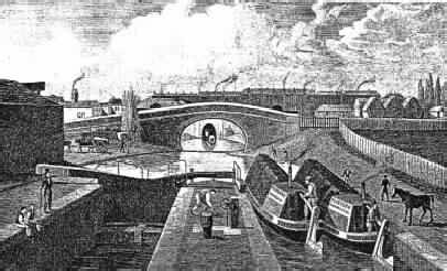
The Ashton Canal Co

Photograph courtesy of Mr Dave Gosling from B Longbone collection
The above picture shows a typical industrial canal scene circa 1906 looking across the newly built Gorton Aqueduct onto wards Ogden Lane bridge. On the right in the foreground is Varna Street school with High Bank Mill behind. On the left hand side is the Gorton Boat Maintenance Yard.

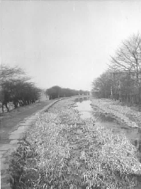
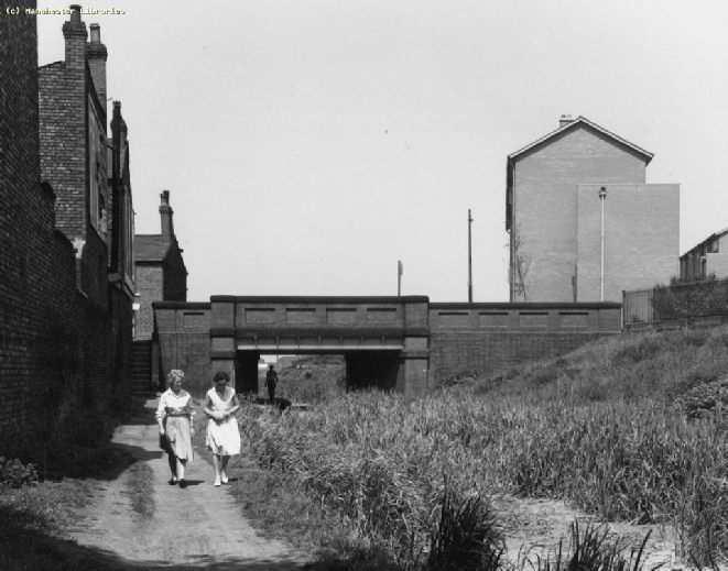
Photograph courtesy of the staff at Brian S. Pope Ltd -
The above photograph shows the canal winding from its terminus at the top of Lancashire Hill out towards what is now the Whitehill Industrial estate. Note how quickly the canal passes through industrial sites and out into farm land. At the top right of the photograph it is possible to see a typical canal hump back bridge. The photograph is believed to have been taken in 1928 presumably during the local wakes week holiday. Note the lack of smoke from the factory and domestic chimneys also the lack of traffic. Many thanks to Mike Kiernan for information which helped to identify some of the locations.
Commercial carrying ceased in the 1930s
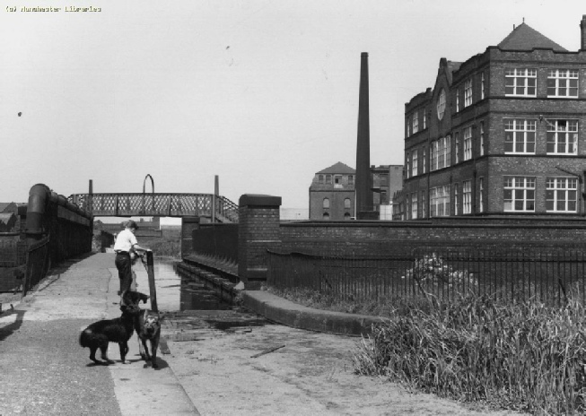
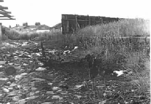
Photograph courtesy of Mr Ken Lowe
Following cessation of commercial traffic, the canal was abandoned and left to its fate. This is a picture taken circa 1962 of a length just north of the Broadstone Road bridge (The Houldsworth Mill is just out of shot on the right) and shows that it does not take long for nature to take over if regular maintenance of these assets is stopped. An abundant growth of plants has literally filled in the canal with the exception of a narrow water channel. The towpath and water wall though look in reasonably good condition.
Gorton Aqueduct looking north 1960
Abbey Hey Lane Bridge looking north 1960
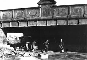
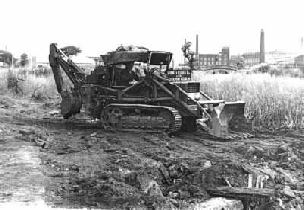
After it’s closure the line of the canal was subject to various works into the 1970s, all designed to remove the canal from the landscape and recover the ground.
Please click here for more information and some 1980’s photos of the canal line,
courtesy of the Pitt-
Time Line along the Stockport Canal:
March 1793 Act of Parliament passed authorising the construction of a canal from Clayton to Heaton Norris.
1793 -
1797 Stockport Canal opened.
1798 A Bill was introduced to allow the abandonment of the Beat Bank branch.
July 1798 The Ashton Canal Co. ordered warehouses to be built at the Stockport end of the canal.
1820 Construction of the Albion Flour Mill.
1825 Construction of Gorton Mill
1845 Construction of the Albert Mill, Greg Street.
1849 Steam Packet started between Openshaw Bridge and Lancashire Hill, Stockport.
1863 -
1893 Albion Flour Mill destroyed by fire and rebuilt. This structure exists today.
July 1806 Agreement to carry coal for the Werneth Colliery terminated.
1903 -
1905 -
1909 Grey Horse public House built at Broadstone Road bridge.
1910 New Broadstone Road bridge open to traffic.
1962 -
3rd February 2004 Manchester & Stockport Canal Society formed to promote the restoration of the canal.
The canal today
About 6 Metres of the canal remain at its junction with the Ashton Canal but the
original route is still visible except for sections at the Stockport end which have
been built over. Its possible to walk with ease the route from Gorton to Clayton
since the filled in canal has been turned into a foot path and cycle path. Parking
is available at Debdale Park
but the
original route is still visible except for sections at the Stockport end which have
been built over. Its possible to walk with ease the route from Gorton to Clayton
since the filled in canal has been turned into a foot path and cycle path. Parking
is available at Debdale Park  at the junction of Hyde road and Gorton Road on the
Debdale Park side of the junction. As far as the Society is aware the original cut
for the canal was not destroyed but simply filled in. Parts of the original waterwall
can still be seen in plac
at the junction of Hyde road and Gorton Road on the
Debdale Park side of the junction. As far as the Society is aware the original cut
for the canal was not destroyed but simply filled in. Parts of the original waterwall
can still be seen in plac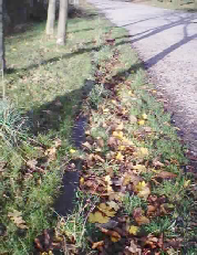 es although some of it has probably been lost due to building
works. All of the bridges between Stockport and North Reddish have been lost but
from Gorton to Clayton the original bridges are largely intact. Its much harder
to find evidence for the existence of the canal at the Stockport end since with the
exception of the Albion Flour Mill the area has been largely redeveloped. There are
however, a few features which may have some relevance to the waterway.
es although some of it has probably been lost due to building
works. All of the bridges between Stockport and North Reddish have been lost but
from Gorton to Clayton the original bridges are largely intact. Its much harder
to find evidence for the existence of the canal at the Stockport end since with the
exception of the Albion Flour Mill the area has been largely redeveloped. There are
however, a few features which may have some relevance to the waterway. 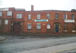 At the corner
of Gordon Street and Lancashire Hill in Stockport is a building which is the modified
remains of Harry Slack’s slaughterhouse that once would have run parallel to the
canal. Notice the arched doorway on the left of the picture which would have given
access to the wharf area.
At the corner
of Gordon Street and Lancashire Hill in Stockport is a building which is the modified
remains of Harry Slack’s slaughterhouse that once would have run parallel to the
canal. Notice the arched doorway on the left of the picture which would have given
access to the wharf area. 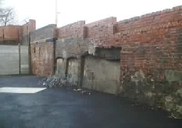 On the left hand side of Wharf Street are the remains of
an old wall the origins of which are unknown but are assumed to be associated with
wharf buildings.
On the left hand side of Wharf Street are the remains of
an old wall the origins of which are unknown but are assumed to be associated with
wharf buildings.
Please click here for more recent photos along the line of the canal courtesy of www.penninewaterways.co.uk
The canal in the future
Please click here to see an article in an issue of the Stockport Heritage Magazine which covers a brief history and the aspirations of the Manchester and Stockport Canal Society for the first part of the restoration from the Ashton Canal to Debdale Reservoir.
Please also click here for some interesting history concerning the construction of the reservoir which started in the 1820’s, courtesy of the Engineering Timelines website.
| News Archive 2022-2023 |
| News Archive 2020-2021 |
| News Archive 2019 |
| News Archive 2018 |
| News Archive 2017 |
| News Archive 2014-2016 |
| News Archive 2004-2009 |
| Events 2019-2020 |
| Events 2017-2018 |
| Archive Events |
| Calendar |
| Meetings |
| Membership |
| Photographs |
| Society Supporters |
| Stockport Canal History |
| Maps |
| Donations |
| MSCS Calendar |
| Society Finance |
| MSCS Achievements |
| Useful Links |
| Reports And AGM Minutes |